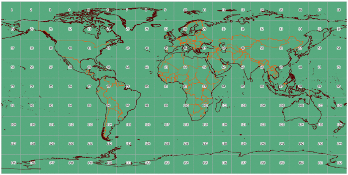
Каталог данных OrbView-3
9 января USGS объявило о том, что стали общедоступны данные OrbView-3 за 2003-2007 гг. Доступ к самим данным дистанционного зондирования осуществляется через инструмент EarthExplorer.
Лицензия данных - Public Domain, что означает что данные можно свободно копировать, распространять, использовать для создания производных продуктов и продавать (ссылка).
-------- Original Message --------
Subject:     Re: Fw: OrbView-3 free images?
Date:     Wed, 11 Jan 2012 15:18:50 -0600
From:     GS-N-EDC Customer Services <custserv at usgs.gov>
To:     hbogner at geof.hr
CC:     Karen A Peterson <kapeterson at usgs.gov>
Hrvoje Bogner
Hello Hrvoje,
Thank you for contacting the USGS Earth Resources Observation and
Science (EROS) Center.
GeoEye's OrbView-3 satellite was amongst the world's first commercial
satellites to provide high-resolution imagery from space.
USGS EROS received approximately 180,000 OrbView-3 image "segments'. The
data that was delivered by GeoEye was a L1B "Basic Enhanced"
radiometrically corrected format.
It is now available to the general public for download at no charge from
the EarthExplorer site. http://earthexplorer.usgs.gov
<http://earthexplorer.usgs.gov/>
Yes, it is public domain. There is no legal requirement for users to
acknowledge or credit USGS as the source for public domain information,
but they may wish to do so as a courtesy. If you wish to acknowledge or
credit USGS as an information source of data or products, use a line of
text as show below.
_http://eros.usgs.gov/#/About_Us/Customer_Service/Data_Citation_
"*Data available from the U.S. Geological Survey*"
Please see this page for further information and details:
_http://www.usgs.gov/visual-id/credit_usgs.html_
Let us know if you have any other questions.
Best regards,
Deb
Каталог данных
Здесь можно получить слой, который можно использовать в ГИС, чтобы получить быстрый ответ на вопрос, покрыта ли моя территория свободнодоступными снимками OrbView. Слой показывает данные на весь мир. Каталог данных можно скачать в виде: слоя в формате Shape: слоя в формате OSM:
Метаданные
Все метаданные по блокам 20х20 градусов можно скачать здесь: http://gis-lab.info/data/orbview-meta
Разграфка блоков
Данный слой был получен посредством импорта метаданных полученных через сервис EarthExplorer
