Creating tiles from QGIS projects using QTiles
по адресу http://gis-lab.info/qa/qtiles-eng.html
Tool for creating tiles from QGIS projects.
This plugin was developed by NextGIS for the UNDP/GEF «Developing GIS-based interactive maps territory control system for pilot steppe reserves» (more in Russian).
Plugin goal — creating multilevel tile cache according to the Slippy Map specification that can be loaded into mobile devices.
| Создано в | Веб ГИС для вашей организации по доступной цене |
Installation notes
Plugin is available via official repository.
QTiles is designed for QGIS version 1.9.0 and higher. There are no dependencies, all necessary files are included in package.
You can also obtain Python sources from our SVN:
git clone https://github.com/nextgis/QTiles
How does it work
After plugin installation and startup by clicking
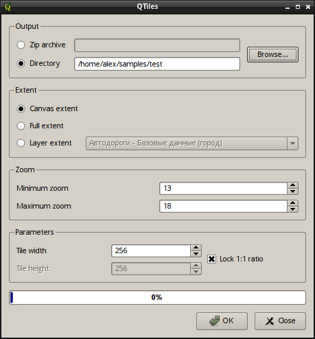
main window will appear
"Output" group is used to select output type: as directory structure or as ZIP-archive. Tiles themselves are saved in PNG format.
Group «Extent» allow to set desired geographic extent of the map. You can select one of the following options:
- Canvas extent — current canvas extent will be used
- Full extent — full extent of all project layers will be used
- Layer extent — output extent will be the same as extent of the selected layer
In «Zoom» group one can set zoom levels. In most cases maximum zoom 18 is enough, but plugin can generate tiles for "deeper" zoom levels. "Depth" depends on the map detalization on certain scales.
"Parameters" group is used to define tile size. Supported values are 128 - 2048 pixels per side.
Press "ОК" to start tile generation and "Cancel" to terminate it.
Contacts
If you want to report a bug or want to make a suggestion — use bugtracker. If you have any other inquiry, you can contact us directly.
