Каталог данных OrbView-3: различия между версиями
Нет описания правки |
Нет описания правки |
||
| Строка 3: | Строка 3: | ||
Лицензия данных - Public Domain, что означает что данные можно свободно копировать, распространять, использовать для создания производных продуктов и продавать ([http://lists.openstreetmap.org/pipermail/talk/2012-January/061546.html ссылка]). | Лицензия данных - Public Domain, что означает что данные можно свободно копировать, распространять, использовать для создания производных продуктов и продавать ([http://lists.openstreetmap.org/pipermail/talk/2012-January/061546.html ссылка]). | ||
<code>-------- Original Message -------- | <code>-------- Original Message --------</br> | ||
Subject: Re: Fw: OrbView-3 free images? | Subject: Re: Fw: OrbView-3 free images?</br> | ||
Date: Wed, 11 Jan 2012 15:18:50 -0600 | Date: Wed, 11 Jan 2012 15:18:50 -0600</br> | ||
From: GS-N-EDC Customer Services <custserv at usgs.gov> | From: GS-N-EDC Customer Services <custserv at usgs.gov></br> | ||
CC: Karen A Peterson <kapeterson at usgs.gov></br> | |||
CC: Karen A Peterson <kapeterson at usgs.gov> | |||
... | |||
USGS EROS received approximately 180,000 OrbView-3 image "segments'. The data that was delivered by GeoEye was a L1B "Basic Enhanced" radiometrically corrected format. | |||
It is now available to the general public for download at no charge from the EarthExplorer site. http://earthexplorer.usgs.gov | |||
Yes, it is public domain. There is no legal requirement for users to acknowledge or credit USGS as the source for public domain information, but they may wish to do so as a courtesy. If you wish to acknowledge or credit USGS as an information source of data or products, use a line of text as show below. _http://eros.usgs.gov/#/About_Us/Customer_Service/Data_Citation_ | |||
Yes, it is public domain. There is no legal requirement for users to | |||
acknowledge or credit USGS as the source for public domain information, | |||
but they may wish to do so as a courtesy. If you wish to acknowledge or | |||
credit USGS as an information source of data or products, use a line of | |||
text as show below. | |||
_http://eros.usgs.gov/#/About_Us/Customer_Service/Data_Citation_ | |||
"*Data available from the U.S. Geological Survey*" | "*Data available from the U.S. Geological Survey*" | ||
Please see this page for further information and details: | Please see this page for further information and details: _http://www.usgs.gov/visual-id/credit_usgs.html_ | ||
_http://www.usgs.gov/visual-id/credit_usgs.html_ | ... | ||
</code> | |||
Версия от 22:41, 12 января 2012
9 января USGS объявило о том, что стали общедоступны данные OrbView-3 за 2003-2007 гг. Доступ к самим данным дистанционного зондирования осуществляется через инструмент EarthExplorer.
Лицензия данных - Public Domain, что означает что данные можно свободно копировать, распространять, использовать для создания производных продуктов и продавать (ссылка).
-------- Original Message --------

Subject:     Re: Fw: OrbView-3 free images?

Date:     Wed, 11 Jan 2012 15:18:50 -0600

From:     GS-N-EDC Customer Services <custserv at usgs.gov>

CC:     Karen A Peterson <kapeterson at usgs.gov>
...
USGS EROS received approximately 180,000 OrbView-3 image "segments'. The data that was delivered by GeoEye was a L1B "Basic Enhanced" radiometrically corrected format.
It is now available to the general public for download at no charge from the EarthExplorer site. http://earthexplorer.usgs.gov
Yes, it is public domain. There is no legal requirement for users to acknowledge or credit USGS as the source for public domain information, but they may wish to do so as a courtesy. If you wish to acknowledge or credit USGS as an information source of data or products, use a line of text as show below. _http://eros.usgs.gov/#/About_Us/Customer_Service/Data_Citation_
"*Data available from the U.S. Geological Survey*"
Please see this page for further information and details: _http://www.usgs.gov/visual-id/credit_usgs.html_
...
Каталог данных
Здесь можно получить слой, который можно использовать в ГИС, чтобы получить быстрый ответ на вопрос, покрыта ли моя территория свободнодоступными снимками OrbView. Слой показывает данные на весь мир. Каталог данных можно скачать в виде: слоя в формате Shape: слоя в формате OSM:
Метаданные
Все метаданные по блокам 20х20 градусов можно скачать здесь: http://gis-lab.info/data/orbview-meta
Разграфка блоков
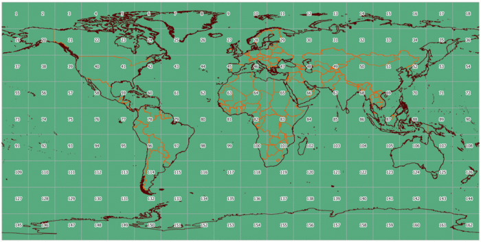
Данный слой был получен посредством импорта метаданных полученных через сервис EarthExplorer
